Welcome Guest ( Log In | Register )

8 Pages  1 2 3 > » Bottom

Outline · [ Standard ] · Linear+

Travel Outdoor activities, hiking & camping, treking, rock climbing & more xtreme act

views
     
Sky.Live
post Jan 10 2012, 04:33 PM

Proctected Species
*******
Senior Member
4,390 posts

Joined: Oct 2004
From: Cheras, Malaysia


I am interested to do this climbathon,

it starts from Hutan Lipur Gunung Datuk, to Puncak Gunung Datuk, Gunung Rembau, Gunung Gagak and back. Anyone know the difficulties in doing these hills?

Cut off time is 5 hours, it's problematic to find lodging place in pedas either
Sky.Live
post Jan 10 2012, 07:11 PM

Proctected Species
*******
Senior Member
4,390 posts

Joined: Oct 2004
From: Cheras, Malaysia


QUOTE(aidono @ Jan 10 2012, 05:36 PM)
I am not really into climbathon but if not mistaken there are a number of series (4 if not mistaken - Gunung Angsi and Gunung Tampin are part it).

Gunung Rembau and Gunung Gagak are for certain chosen categories.
*
I am interested to know the distance apart of them, and difficulties for them. 5 hours return is not an easy time if it's a very technical climb (I did Mulu Pinnacles and it's not very easy at all)
Sky.Live
post Jan 10 2012, 08:45 PM

Proctected Species
*******
Senior Member
4,390 posts

Joined: Oct 2004
From: Cheras, Malaysia


QUOTE(aidono @ Jan 10 2012, 07:53 PM)
They already separate by categories.

Category:
Men Open (22-39 years)
Women Open (22 years and above)
Men Veteran (40 years and above)
Men Junior (18-21 years)
Women Junior (18-21 years)
School Boys (13-17 years)
School Girls (13-17 years)

Distance:
Men open - 16km
Women open and Men Veteran - 11km
Junior and School - 8km

16km - 5 hours relatively moderate. It ain't going to be like Pinnacles/ Kinabalu. Best of luck ya.  wink.gif
*
So I just have to drive to Hutan Lipur Rembau right? I am totally lost with that area
Sky.Live
post Jan 11 2012, 05:16 PM

Proctected Species
*******
Senior Member
4,390 posts

Joined: Oct 2004
From: Cheras, Malaysia


QUOTE(aidono @ Jan 11 2012, 09:22 AM)
Have you hike Gunung Datuk before?

If you have a GPS, key in N 2 32.574, E 102 10.140
*
I will try it during CNY period I guess, prior the race. I guess all 3 mountains shud be connected quite nearby
Sky.Live
post Jan 14 2012, 07:59 PM

Proctected Species
*******
Senior Member
4,390 posts

Joined: Oct 2004
From: Cheras, Malaysia


user posted image

Looks like it's 16k, and the furthest and lowest peak among all category


Added on January 17, 2012, 9:28 am Any regular kaki here?

Where is the popular hiking trail around klang valley?
1) Bukit Saga (my training spot)
2) Broga (too crowded IMO)
3) Gasing - never been before
4) Bukit Tabur - would want to go again, only done once
5) Gunung Nuang / Camp Pacat - Never did but interested to do at least once
6) Templer park - if you consider that as hike it's quite nice actually
7) any other?

This post has been edited by Sky.Live: Jan 17 2012, 09:28 AM
Sky.Live
post Feb 13 2012, 05:51 PM

Proctected Species
*******
Senior Member
4,390 posts

Joined: Oct 2004
From: Cheras, Malaysia


QUOTE(aidono @ Jan 17 2012, 03:25 PM)
Bukit Rasa, Rawang
Bukit Tabur, Melawati - Got three (East,West,Extreme)
Bukit Kutu, KKB
Gunung Chenuang, Hulu Langat
Gunung Nuang, Hulu Langat
Gunung Hitam, Hulu Langat
Gunung Ulu Semangkuk, Fraser's Hill
Pine Tree & Twin Peak, Fraser's Hill
*
Thanks for your help I have done it,

Here is the GPS data for the hike,
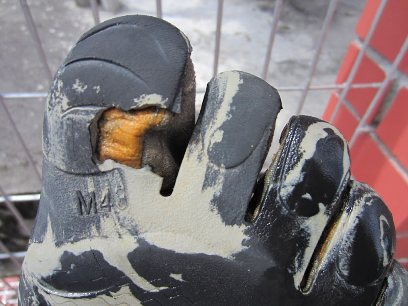
http://www.trainingpeaks.com/sw/ETN7OBTBT7BEVNCHBCXMLUYPPM

It's really difficult and as kids, uncles, auntie pass by me like nothing, I am the last person from start. I think i need to shred a lot of weight to be good. Also spoiled my newly bought VFF for this.. heart broken now T_T..

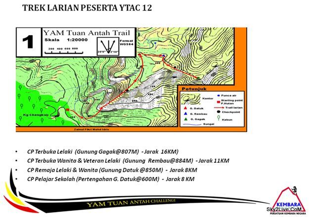
But have a great experience of knowing what a climbathon is, also Gunung Datuk is a good training spot, straight ascending to near 900m too me 1:15 to do that = ="

QUOTE(pilotHans @ Jan 19 2012, 03:10 PM)
update 1st Entry plz . can even put the names of people who went there..so next time some newbies in the topic(like me  blush.gif ) i know who to ask/pm perhaps? smile.gif

Hiking trail around klang valley
1) Bukit Saga (my training spot)
2) Broga (too crowded IMO)
3) Gasing - never been before
4) Bukit Tabur, Melawati - would want to go again, only done once
5) Gunung Nuang / Camp Pacat - Never did but interested to do at least once
6) Templer park - if you consider that as hike it's quite nice actually
7) Bukit Rasa, Rawang
8) Bukit Kutu, KKB
9) Gunung Chenuang, Hulu Langat
10) Gunung Nuang, Hulu Langat
11) Gunung Hitam, Hulu Langat
12) Gunung Ulu Semangkuk, Fraser's Hill
13) Pine Tree & Twin Peak, Fraser's Hill
14) Sg Chiling, KKB.  - pilotHans - went camping there 1st week of Jan  icon_idea.gif

Hiking in Pahang
-lata hammer?

Hiking in Perak
-

Hiking in N9
-gunung angsi /ulu bendul

just my suggestion  icon_idea.gif
*
I just realise we have the same
1) same
2) agree
3) same
4) done once too
5) Interested to do too
6) Templer park, yeah it's nice, i used to go there once a week when I was a kid.

Others not done b4

Pahang - never did b4
N9 - Mt KK if you consider

Others - Sarawak Mulu Pinnacles

maybe we can meet up someday for gunung nuang
Sky.Live
post Feb 14 2012, 11:50 AM

Proctected Species
*******
Senior Member
4,390 posts

Joined: Oct 2004
From: Cheras, Malaysia


QUOTE(aidono @ Feb 14 2012, 08:34 AM)
Lata Naning can be reachable expecially for normal waterfall visitors. It is just the matter you can get used to long distance trekking. Lata Naning got two falls (I am referring to 50 - 100m height only).

Lata Medang also the same. Located at Kampung Pertak, KKB and got two falls. One you can enjoy the pool and the other you can't. One thing for sure, Lata Medang would be a great place to take photography if you are into one. Be aware that the route heading to Medang might have lots of snake sad.gif and durian smile.gif


Added on February 14, 2012, 8:40 am

Vibram Five spoilt? I just wonder how did you do that  unsure.gif .
*
how? not sure..

but anyway
user posted image

I am not interested in long hike in particular, dislike camping anyway.. hope that there's a one day hike which don't have to carry too much stuff.. carrying water alone is tiring enough

This post has been edited by Sky.Live: Feb 14 2012, 11:54 AM
Sky.Live
post Apr 25 2012, 12:21 PM

Proctected Species
*******
Senior Member
4,390 posts

Joined: Oct 2004
From: Cheras, Malaysia


Start with something easy
EG: kiara trails, Gasing, Broga, Saga, FRIM

Do start with a day hike, u just need to bring water and a phone (emergency contact, possible with gps connection). Get someone who know the trail, start your trail

These are good for training.. Those trail mentioned above are sort of recommended training ground regardless of your fitness trail.

Then maybe you can proceed to Nuang or other mountains..

I am not a person in favour of camping either.. But more of a person who like day hike/trail run.. Running in the jungle is so exciting because a small mistake can cause a big injuries..
Sky.Live
post May 3 2012, 08:44 AM

Proctected Species
*******
Senior Member
4,390 posts

Joined: Oct 2004
From: Cheras, Malaysia


I have plans for Gunung Nuang this Sunday.. excited and not sure how would we do it
Sky.Live
post May 4 2012, 05:48 PM

Proctected Species
*******
Senior Member
4,390 posts

Joined: Oct 2004
From: Cheras, Malaysia


Drafted out my Nuang's plan.. set my finger crossed for this sunday. Kinda pressured as I am the organiser haha..

Summit attempt will depend on the group speed, the last thing you want to happen is someone being left behind.

I want to do Tabur again given the chance.. done once few years back.. Quite a challenging one..
Sky.Live
post May 6 2012, 10:33 PM

Proctected Species
*******
Senior Member
4,390 posts

Joined: Oct 2004
From: Cheras, Malaysia


Done Nuang.. but did not reach summit almost there.. we you turn 30 minutes from camp pacat after thunder sounded.. we did quite well i think 3hrs to reach camp pacat..

GPS data for anyone interested
http://www.trainingpeaks.com/sw/JGUPRQVHEC35XNL3OHKB6BNTRU
Sky.Live
post May 7 2012, 09:09 AM

Proctected Species
*******
Senior Member
4,390 posts

Joined: Oct 2004
From: Cheras, Malaysia


I think it will goes better under sport subgroup.;.
Sky.Live
post May 7 2012, 11:13 AM

Proctected Species
*******
Senior Member
4,390 posts

Joined: Oct 2004
From: Cheras, Malaysia


another problem is that not much popularity in these.. so having a specific topic would be difficult too.. generally you dont get to see much update over this thread either
Sky.Live
post May 7 2012, 12:20 PM

Proctected Species
*******
Senior Member
4,390 posts

Joined: Oct 2004
From: Cheras, Malaysia


Hopefully I would be able to organise another Nuang Summit attempt revenge hike in near future haha.. This time much prepared
Sky.Live
post May 7 2012, 02:04 PM

Proctected Species
*******
Senior Member
4,390 posts

Joined: Oct 2004
From: Cheras, Malaysia


QUOTE(Naughtybones @ May 7 2012, 01:56 PM)
Hiya sky.live  what watch do u use for the trip? Can any watch with a gps be used to download into training peaks?
*
phone also can.. just that not sure if your battery can last that long or not..
Sky.Live
post May 7 2012, 02:18 PM

Proctected Species
*******
Senior Member
4,390 posts

Joined: Oct 2004
From: Cheras, Malaysia


QUOTE(Naughtybones @ May 7 2012, 02:06 PM)
Just read their faq, they dont support my particular suunto model. What watch r u using?
*
Timex Global Trainer.. Trainingpeak is the only website that "officially" support my watch.. I wanted to use dailymile initially..

You are using Garmin?
Sky.Live
post May 8 2012, 12:59 AM

Proctected Species
*******
Senior Member
4,390 posts

Joined: Oct 2004
From: Cheras, Malaysia


QUOTE(Naughtybones @ May 7 2012, 06:26 PM)
Im using d suunto ambit with movescount. Do the timex global trainer have issues with speed below 10kmph? I mean do u get a smoth graph?
Use a footpod for smooth chart, or use pace smoothing.. but then mine it spikes like mad too..

QUOTE(PseudoGene @ May 7 2012, 06:48 PM)

Wow... good luck then. Just wondering, how long do you think would it take to reach the summit?
*
for my group i am estimating less than 5hrs to reach summit.. pace of beginner around 5~6hrs
Sky.Live
post May 8 2012, 09:25 AM

Proctected Species
*******
Senior Member
4,390 posts

Joined: Oct 2004
From: Cheras, Malaysia


QUOTE(PS3.Gamer @ May 7 2012, 03:03 PM)
Actually, I don't have an iOS device. I can't use those. I need a physical tracker.


Added on May 7, 2012, 3:05 pm

I don't have a shoe yet, no. I'm just going to get a simple running shoe. Will check out Studio R or something? Actually, now that you are at it, where to get proper shoes being sold my salesmen that can give me advice too?


Added on May 7, 2012, 3:09 pm

Hey, thanks for that website man! The options are plenty, and I think I'll definitely find what I'm looking for from them! Will check out Athlete's Circle too. This is great, thanks again!


Added on May 7, 2012, 3:11 pm

I'm more concerned about tracking calories and such, not so much interested in the GPS. It seems like I may need more than one device.
*
Calories for my watch it's analyse via Heart Rate, not the most accurate method around. Almost all GPS watch track calories burning too. Those without GPS are much cheaper

If you are really hardcore about getting accurate calories burned measurement:
http://www.dcrainmaker.com/2010/11/how-cal...-on-garmin.html

I did mine via HRM i think the accuracy is kinda doubted.

My sunday hiking: https://www.trainingpeaks.com/sw/JGUPRQVHEC35XEQFR6ON2FTEWY
I burned 6.1k of calories? and it's not really strenuous at all..

BTW for shoe, sad to say it would be try and error basis, you would need try a few shoe until you know what you want, what the salesperson says is kinda BS mostly to me. I change 4 pairs of running shoe in 7 months running to settle with what I find comfortable. Also as you do your activities longer (eg: run faster, run longer) you would find new problems that never arise. Buying shoe is like tasting wine, you need time, sometimes you get the wrong one, but that's how you learn. You might get lucky to find your beloved one first tries.

Try getting off season shoe (previous models) it's usually heavily discounted 30~50%. Don't worry about durability, shoes doesn't last very long IMO.

QUOTE(hackwire @ May 8 2012, 07:33 AM)
I think it's tru. I went up bit gassing that day n saw a few thugs r feeding monkeys there. There r 3 of them with swollen face. Better to go during peak hours. I did not know bit kiara has a hiking path. Nice?
*
Bukit Kiara is more like a mountain bike trails rather than hiking trails. Not high not long enough for hiking.

QUOTE(Naughtybones @ May 8 2012, 08:17 AM)
Apparently d ambit is not compatible with d footpod yet. Hope they will upgrade it in d coming firmware. And yea using a footpod will prolly get a more accurate speed while walking
*
Footpod is a small sensor that you place on your shoe lace, sort of accelerometer to detect your leg shift pattern to determine your running distance.

QUOTE(hackwire @ May 8 2012, 08:28 AM)
Anyone been to lentang. There's a camp site . I wonder if therea a hiking trail there.
*
I was invited by a group to go there early next month, via 4WD not hiking. I went there back few years ago. It's a really nice place
Sky.Live
post May 8 2012, 01:43 PM

Proctected Species
*******
Senior Member
4,390 posts

Joined: Oct 2004
From: Cheras, Malaysia


I never camp in my life, thus to date I only do day hike haha.. hate to carry bulks of things when I do exercises.. I am not that "outdoor" kind of people. Lacking of survival skill can cost you a lot during an outdoor event, even day hike. I'm still trying to learn, touch wood so far so good haven't encounter any major incident yet. I cant imagine one day if i fall down and have crawl all the way down..
Sky.Live
post May 9 2012, 09:25 AM

Proctected Species
*******
Senior Member
4,390 posts

Joined: Oct 2004
From: Cheras, Malaysia


QUOTE(PseudoGene @ May 8 2012, 09:50 PM)
Thanks! I guessed it's going to take a whole to hike up and down then.


Added on May 8, 2012, 9:54 pm

Oh..i see i see. Thanks for the heads up! Bukit Kiara, nothing much to hike. It's basically a tar road and a bit hilly at certain parts. I think half an hour can go 2 rounds already. More of a leisure walk/jog, rather than hiking. I would say Gunung Angsi is better. If you are taking the Bukit Putus route, the beginning part is similar to the Pinnacles in Mulu. And after the hike, there are free 'tong sui', fruits and drinks!  brows.gif
*
You can go off road, those trails are really nice to run in.. too short for hike IMO

8 Pages  1 2 3 > » Top
 

Change to:
| Lo-Fi Version
0.0499sec    0.35    7 queries    GZIP Disabled
Time is now: 24th December 2025 - 11:17 AM