Welcome Guest ( Log In | Register )

Outline · [ Standard ] · Linear+

 Next 24 hours critical as Tropical storm Senyar, Hits KL, Selangor and Pahang

views
     
TSZeroSOFInfinity
post Yesterday, 05:41 PM, updated 13h ago

Look at all my stars!!
*******
Senior Member
3,703 posts

Joined: Oct 2005


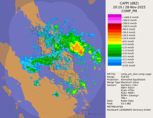
PETALING JAYA: The next 24 hours will be critical for Kuala Lumpur, Selangor and parts of Pahang as Tropical Storm Senyar is expected to pass through these areas before heading across the rest of the country.

MetMalaysia director-general Dr Hisham Anip said rainfall of between 200mm and 300mm is expected during this period. The rain is expected to ease by Sunday as the storm moves into the South China Sea.

shocking.gif

“This is the first time MetMalaysia has observed such a storm forming in the Straits of Malacca,” he said during a press conference here.

“Strong winds of up to 50km/h are expected from today and will continue for at least the next 24 hours.

“Malaysia usually experiences winds of only 10 to 20km/h, but Tropical Storm Senyar has intensified due to warm sea temperatures and La Niña conditions,” Hisham explained.

He advised the public to drive cautiously and to keep important documents in a safe place during the storm.

Hisham also said MetMalaysia is providing regular weather updates to KLIA authorities.
g5sim
post Yesterday, 06:01 PM

Look at all my stars!!
*******
Senior Member
5,750 posts

Joined: Jan 2003
From: Sri Kembangan


QUOTE(ZeroSOFInfinity @ Nov 27 2025, 05:41 PM)
PETALING JAYA: The next 24 hours will be critical for Kuala Lumpur, Selangor and parts of Pahang as Tropical Storm Senyar is expected to pass through these areas before heading across the rest of the country.

MetMalaysia director-general Dr Hisham Anip said rainfall of between 200mm and 300mm is expected during this period. The rain is expected to ease by Sunday as the storm moves into the South China Sea.

shocking.gif

“This is the first time MetMalaysia has observed such a storm forming in the Straits of Malacca,” he said during a press conference here.

“Strong winds of up to 50km/h are expected from today and will continue for at least the next 24 hours.

“Malaysia usually experiences winds of only 10 to 20km/h, but Tropical Storm Senyar has intensified due to warm sea temperatures and La Niña conditions,” Hisham explained.

He advised the public to drive cautiously and to keep important documents in a safe place during the storm.

Hisham also said MetMalaysia is providing regular weather updates to KLIA authorities.
*
🎉🎉. Will bring color to Malaysia some said
dest9116
post Yesterday, 06:07 PM

Casual
***
Junior Member
495 posts

Joined: Apr 2019
Tadak pun, sembang je kencang
carmensandiego
post Yesterday, 06:07 PM

New Member
*
Newbie
3 posts

Joined: Sep 2017

as usual delayed news by MET Malaysia.

this should have been released yesterday inline with the predicted path of Senyar after it hit Medan. JTWC has already stopped updating as the storm reduced to a tropical depression due to unfavorable conditions earlier today.

Should dissipate completely by end of today based on the current predictions.

Not a weather expert but the experts actually release 2-3 hour updates. Just relaying the information.
Pain4UrsinZ
post Yesterday, 06:12 PM

Regular
******
Senior Member
1,856 posts

Joined: Dec 2008
From: In The HELL FIRE


Still safe to travel on plus high way? Sohai friend wedding dinner these weekends
kcchong2000
post Yesterday, 06:14 PM

Getting Started
**
Junior Member
189 posts

Joined: Jan 2009
MET cakap lepad Keyel mana tau pigi keklantan
Jigoku
post Yesterday, 06:15 PM

Getting Started
**
Junior Member
288 posts

Joined: Jan 2010

Sudah habis la, Malaysia safe

MeT slowpoke as usual
rtk73
post Yesterday, 06:15 PM

Getting Started
**
Junior Member
212 posts

Joined: Jan 2023
QUOTE(carmensandiego @ Nov 27 2025, 06:07 PM)
as usual delayed news by MET Malaysia.

this should have been released yesterday inline with the predicted path of Senyar after it hit Medan. JTWC has already stopped updating as the storm reduced to a tropical depression due to unfavorable conditions earlier today.

Should dissipate completely by end of today based on the current predictions.

Not a weather expert but the experts actually release 2-3 hour updates. Just relaying the information.
*
Maids hometown hit and flooded
MR_alien
post Yesterday, 06:16 PM

Mr.Alien on the loss
*******
Senior Member
3,580 posts

Joined: Oct 2007
From: everywhere in sabah


QUOTE(Pain4UrsinZ @ Nov 27 2025, 06:12 PM)
Still safe to travel on plus high way? Sohai friend wedding dinner these weekends
*
if you google it, it is already leaving klang valley

predicted to make a U-turn after it reached indon but to ipoh

https://zoom.earth/storms/senyar-2025/

This post has been edited by MR_alien: Yesterday, 06:21 PM
xander2k8
post Yesterday, 06:17 PM

Look at all my stars!!
*******
Senior Member
4,637 posts

Joined: Jan 2003
QUOTE(carmensandiego @ Nov 27 2025, 06:07 PM)
as usual delayed news by MET Malaysia.

this should have been released yesterday inline with the predicted path of Senyar after it hit Medan. JTWC has already stopped updating as the storm reduced to a tropical depression due to unfavorable conditions earlier today.

Should dissipate completely by end of today based on the current predictions.

Not a weather expert but the experts actually release 2-3 hour updates. Just relaying the information.
*
The problem is with MET they way disseminate public information 🤦‍♀️ coupled with delayed news causing lack of preparation ahead of such events

You can tell from how the authorities preparedness hence why you can see ppl saving their cars especially under heavy rain
emburrar
post Yesterday, 06:19 PM

New Member
*
Newbie
14 posts

Joined: Oct 2014
From: Bandar Damai dan Indah


Banjir lagi ke
19 Degree South
post Yesterday, 06:28 PM

Regular
******
Senior Member
1,674 posts

Joined: Oct 2012
god bless puchong
Atrocious
post Yesterday, 06:44 PM

Getting Started
**
Junior Member
96 posts

Joined: Oct 2022
Stay in, avoid travel, don't park car under trees then duct tape your sliding glass windows and doors. It's coming..
Wedchar2912
post Yesterday, 06:51 PM

Look at all my stars!!
*******
Senior Member
3,587 posts

Joined: Apr 2019
“This is the first time MetMalaysia has observed such a storm forming in the Straits of Malacca,” he said during a press conference here.


so once in 1500 years event???
DDG_Ross
post Yesterday, 06:52 PM

New Member
*
Junior Member
27 posts

Joined: Feb 2014
From: Somewhere in the pacific, or indian ocean


latest storm is downgraded to tropical depression but still will bring lots of rain


WhatMan
post Yesterday, 06:55 PM

Regular
******
Senior Member
1,620 posts

Joined: Oct 2010


QUOTE(Wedchar2912 @ Nov 27 2025, 06:51 PM)
“This is the first time MetMalaysia has observed such a storm forming in the Straits of Malacca,” he said during a press conference here.
so once in 1500 years event???
*
They probably meant first time since establish of MetMalaysia.
ihm11
post Yesterday, 07:25 PM

Getting Started
**
Junior Member
62 posts

Joined: Apr 2018
#pray4kl
upcars
post Yesterday, 07:44 PM

Getting Started
**
Junior Member
93 posts

Joined: Feb 2017
20cm rain is not funny. U add in ponding and slow dispersion fuhhh
Boomwick
post Yesterday, 08:00 PM

Enthusiast
*****
Junior Member
978 posts

Joined: Mar 2019
QUOTE(upcars @ Nov 27 2025, 07:44 PM)
20cm rain is not funny. U add in ponding and slow dispersion fuhhh
*
20cm evenly kena then ok.

But when 1 area start to collect every area punya 20cm, tat become 2meter
Hollow21
post Yesterday, 08:07 PM

On my way
****
Junior Member
661 posts

Joined: Jul 2011
Peak this midnight then continue rain until Saturday.

Afterthat onwards to Kelate. Gg already kena whacked together with Hatyai

andyng38
post Yesterday, 08:13 PM

Look at all my stars!!
*******
Senior Member
2,398 posts

Joined: Jun 2007
QUOTE(Pain4UrsinZ @ Nov 27 2025, 06:12 PM)
Still safe to travel on plus high way? Sohai friend wedding dinner these weekends
*
ensure your tyres have enough tread on them, and the air pressure in them is at the proper amount. you'll want the tyres to be in the best shape to channel water away as fast as they were designed to do.

your brakes should also be working properly.

drive at a moderate speed and keep your head on a swivel to look out for obstacles and idiots on the road.

have a safe journey.
Skidd Chung
post Yesterday, 08:16 PM

Casual
***
Junior Member
479 posts

Joined: May 2010


Storm already hit Malaysia, so far how is it?
saigetsu
post Yesterday, 08:52 PM

Enthusiast
*****
Senior Member
707 posts

Joined: Feb 2010


already passed. kl puchong subang looks ok based on forecast


Change to:
| Lo-Fi Version
0.0177sec    0.54    5 queries    GZIP Disabled
Time is now: 28th November 2025 - 06:44 AM