Welcome Guest ( Log In | Register )

Outline · [ Standard ] · Linear+

 Enso Woods, Gamuda Cove, Japanese inspired minimalist homes

views
     
magicforumer
post Mar 24 2022, 06:30 PM

Getting Started
**
Junior Member
64 posts

Joined: Dec 2021
QUOTE(stephen5215 @ Mar 20 2022, 06:48 PM)
Want to ask, is the illegal oil palm burning issues still critical there? And is GC risky to flood like wat happened recent months?
*
GC township borders the North Kuala Langat Peatswamp Reserve. The last major fire event was in 2014 which burned 50% of the forest due to dry surface peat conditions/drought. The large tea plantation east of the reserve likely also drained out a lot of the soil moisture required for crop growth & viability.

To maintain moisture levels, Jabatan Perhutanan has since then blocked the drainage ditches (which were then purposed for logging) in the Peatswamp Reserve, together with surveillance/law enforcement such as restricted entry/fines. The community living east of the forest have a role to protect their heritage & culture.

The last forest fire at the Northern Langat Peatswamp was a tiny one in 2021. The burnt areas during previous years have been under Rehab/tree replanting etc. Just last week, there were calls for Selangor to officially regazette this peatswamp back to Reserve status.

The highest rainfall Selangor documented December 2021 was unexpected due to continuous rain. Nearby Dengkil town was badly flooded as it was next to Langat river. The retention ponds in GC at that time were able to contain the rainfall and had part of the "jogging trails" submerged.

Try Google:
bernama demi survival hutan simpan kuala langat
magicforumer
post Apr 2 2022, 10:18 PM

Getting Started
**
Junior Member
64 posts

Joined: Dec 2021
QUOTE(kimzee @ Mar 30 2022, 11:36 PM)
good point.....
Last month when setia alam was experiencing its worst nightmare, the whole stretch of slip road left and right  beside elite  highway from Dengkil to BSP highway was flooded.

I saw it firsthand. Will flooding gets better in years to come? You tell me.
*
I believe areas at riverbanks have a higher risk. Take Taman Sri Muda for example located at the riverbank for Sg Klang, or Taman Mutiara Dengkil at the riverbank of Sg Langat, which were badly affected.

Banjir Malaysia 2021 was taken as a 100-year flood event with 1% probability of occurrence in any year, where Selangor had 2X MORE than highest ever recorded rainfall.

Given the continuous rainfall in almost all major states, I would say it was a more accurate representation of the flood map than your usual dry season flash floods. With that, you get to gauge the flood risk of your taman. If your taman was unaffected, then most likely your taman will be safe. To balance between government budget and maintenance, most Klang Valley flood prevention systems are based on 50-years ARI (Annual Recurrence Interval), meaning average of 50 years in between flood events (could be earlier or later, and a 2% chance of occurrence at any year aka AEP, Annual Exceedance Probablity).

GC to Rimbayu via ELITE Highway was okay. Even Cyber too. And also Putrajaya Dam which protected many downstream tamans along Sg Langat, but flood risk will always change with development and global warming. Will we still be around in the next 50 years? Haha.

You can Google "MWA Webinar 3/2022" to hear more from our expert weatherman.
magicforumer
post Apr 2 2022, 10:20 PM

Getting Started
**
Junior Member
64 posts

Joined: Dec 2021
QUOTE(BullishBear @ Mar 31 2022, 10:44 AM)
how WCE connect GC to Shah Alam?
*
Most likely Kampung road to Banting and then to Teluk Panglima Garang and then to WCE.
magicforumer
post May 2 2022, 01:45 AM

Getting Started
**
Junior Member
64 posts

Joined: Dec 2021
QUOTE(macians @ Apr 9 2022, 12:41 AM)
I am currently staying at Taman Arked, Dengkil since 2016. Taman Arked, Paya Indah Wetland & PLKN Kuala Langat (now converted into Penjara Satelit Kuala Langat) is the nearest neighbourhood of GC.

To access this area, you need to come from Jalan Dengkil-Banting from Pekan Dengkil or Bukit Changgang. since 2017, this is one of the off-road access for all lori tanah Gamuda to come into GC. Another access is from Bukit Cheding if i’m not mistaken. Based on GC masterplan layout, this will be nearby their southern development (semi-d/bungalow).

Actually, Cybersouth project and GC is just next to another. Separated by Elite highway. From Jalan Dengkil-Banting you can access Cybersouth area using off-road passsing by the legendary abandoned Sri Dengkil Mining Dredge.

Geographically, there are lot of abandoned mines around this area esp nearby Paya Indah Wetland. Taman Arked is not affected by the recent Dec2021 flood disaster & i guess it is almost impossible for this area to be affected since there are lot of deep abandoned mines which can be the kolam takungan air hujan. Plus, there is a lake of crocodile (buaya tembaga) inside the Paya Indah Wetland. I think if this area banjir for sure all the buaya will go out lah.

To be frank just be careful with other lakes/mines around this area, there are few cases of crocodile been spotted nearby Taman Arked & Paya Indah Wetland areas.

Structure wise, i hope Gamuda can do better than OIB. Most of terrace houses at Taman Arked experienced ‘tanah mendap’. Some of local ppl here said this is because of the water movement  due to kawasan paya & lombong.
*
Sorry to hear about the condition in your taman. Soil profiling has long been investigated even before the commencement of Taman Arked housing construction back in 2006. Settlement always happens to all construction sites, hence the need for more ground improvement to compensate for it especially in soft soil with low bearing capacity.

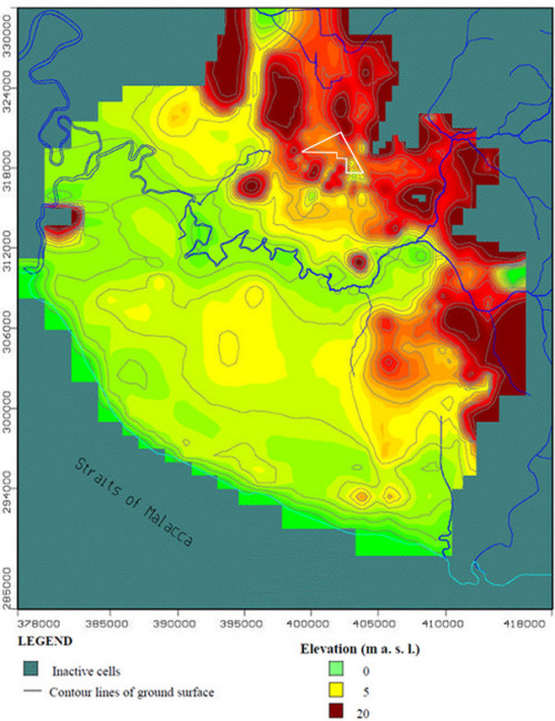
Based on regional borehole data & subsurface soil analysis in the labs, higher compressibility was observed generally around Banting area, followed by medium compressibility surrounding the banks of Langat River & around KLIA, and a lower compressibility nearby Paya Indah territory.

In the past, settlement has largely occurred around the Langat river due to drawdown of groundwater from commercial water pumping. Since then, tight regulatory processes/licensed permits have been implemented to reduce degradation, such as increasing co-management between private & government in groundwater management to reduce peatfires/maintain soil equillibrium, as well as Paya Indah rehab with periodic EIA reports (Environmental Impact Assessment).

Agree with you regarding flood from rising sea levels being the least of concerns given the higher ground elevation. However, maintaining the groundwater equillibrium will be important to prevent untoward/accelerated settlement, with high hopes on developers to deliver through their engineering expertise.

user posted image
user posted image


Change to:
| Lo-Fi Version
0.0205sec    0.42    7 queries    GZIP Disabled
Time is now: 17th December 2025 - 03:12 PM