QUOTE(PaulKong @ Sep 20 2015, 10:35 PM)
Wah... Genting sempah. Actually, I want to know, how hard is the ride there? Are there only one route or there are easy, medium and hard route 😁😁😁
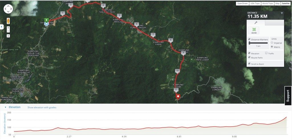
Genting Sempah (GS), to those who usually rides, is a one way up and one way down. It's 16 kilometers to where most usually turn back. The moment you start, it will climb very gradually and then past the 4th kilometers the inclination gets steeper and thenon the last two kilometers, it gets even steeper. So, it all climb! Then after resting, it's all the way down to the car park. Going down is even more dangerous, especially at the bridge, where there are gaps on the road. That answered, it is only one mode " medium/hard ".
In GS, you ride 16 kilometers to an elevation of approximately 634 meters ASL. Many riders after getting seasoned with the route, they will continue down to McDonalds (where the actual GS is) and then ride back UP

Many roadbikers continue to Janda Baik and even Bentong.
In contrast, Genting Peras (GP) is actually easier or harder , depending on your riding style. In GP, you usually start from the 18th mile Ulu Langat police station. Then it is a 12 kilometer flattish ride, gaining an elevation of 130 meters over 12 kilometers. Quite easy actually. Many riders likes to ride here as the road is cleaner, air is fresher and not as many lorries plying as GS. To those who wants an easier ride, they will turn back after reaching the junction. The last 500 meters is quite steep so most will be puffing already, demoralizing many and wants to turn back.
The next section, the tougher section, is 10.5 kilometers to 600 meters ASL. Some parts will be steep, especially the 1km stretch just after the junction and also the last kilometer. With some sporadic sections that are steep, it will sap many new riders. The hardest part (to many seasoned GS riders) is the after getting back down to the junction is the last 12 kilometers flat road back to Ulu Langat. Unlike GS, you suffer the ride up but it's downhill all the way.
I personally prefer GP because I find the smell of rotten food hard to bear on the GS stretch. There are many restauranteurs who dump their garbage down the slopes beside GS road. The smell can get over bearing at times. But most definitely, both of these routes is tougher than FRIM

PS/ Most riders don't realize that actually Fraser's Hill is an easier ride. I noticed many riders don't really study the routes. In Fraser's Hill, there is no compulsion to where you want to start or where you want to end. It's only the riders who thinks one must complete the KKB to Fraser's clock tower. I rode 6 times and only twice I do it to the clock tower. I find the last 8 kilometers (very steep) not worthwhile. You see, you have already done 33 kilometers and really tired, why suffer the last 8 km.
To really get use or learning to ride hilly terrain, skip the KKB to Sg.Chilling part first. Park your car in Sg.Chilling. Riders are earlier than hikers so the car parking in front of the drinks stall is available. Someone to look after the car, mah!

You start here and ride uphill (it's actually very gradual, even horse cart can navigate up). 20 kilometers , you reach GAP. If you don't , doesn't matter as turning back is all the way down, just coasting. !3 kilometers you will reach the waterfall. So, just ride as hard as you can and if you cannot, coast back to the car. Eventually, it be become easy and when you reach that stage, you can start from KKB or occasionally ride the last 8km to the clock tower and take that symbolic picture.
Sadly, I see a lot of riders, drive up there and take the pictures as well.


 Sep 18 2015, 12:25 PM


 Quote
Quote


 Looking at the "wow!" factor that you mentioned, I can guess where your inclinations are. heheheee.
 ...
...

 0.0415sec
 0.72
0.72
 7 queries
 GZIP Disabled