

 Jun 17 2012, 10:27 PM, updated 9y ago


*** The More REFRESHED & VIBRANT Discussion Thread on Denai Alam - from the legacy of the initial THREAD***
"The most prestigious neighborhood in the Klang Valley."
OVERVIEW
Denai Alam is located along the Guthrie Corridor Expressway and about 5 km north of Bukit Jelutong. The Denai Alam township is planned according to unique “Denai” concept which is a 4.8 km continuous green space surrounding the development.
Planned as mixed development, the 920 acre Denai Alam consists of 5967 freehold mixed residential and commercial units. The township which was launched in November 2004, is a low density development with only 8 units per acre.

Denai Alam was inspired by the traditional Malay kampong that stresses on communal living in a modern neighborhood with traditional charm. A place where landscaped footpath or denai serves as dedicated path for pedestrians and non-motorized vehicles.
This development was awarded 2003 Planning Innovation Award from the Malaysian Institute of Planners.

-------------------------------------------------------------------------------------------------------------------------------------
Launched November 2004
-------------------------------------------------------------------------------------------------------------------------------------
Location Along the Guthrie Expressway and neighbouring Bukit Jelutong
-------------------------------------------------------------------------------------------------------------------------------------
Total Acreage 1,000 acres
-------------------------------------------------------------------------------------------------------------------------------------
Land Tenure Freehold
-------------------------------------------------------------------------------------------------------------------------------------
Accessibility
• From Shah Alam, Subang, Sungai Buloh and Kota Damansara via:
• Guthrie Corridor Expressway
• New Klang Valley Expressway (NKVE)
• ELITE Highway
• KESAS Highway
• Easy access from Mutiara Damansara and Mont Kiara via the Sprint-Penchala link
-------------------------------------------------------------------------------------------------------------------------------------
Amenities
• Kelab Golf Sukan Abdul Aziz Shah
• Bukit Cahaya Seri Alam Agricultural Park
• Clinics, Schools and Shops
-------------------------------------------------------------------------------------------------------------------------------------
Awards
• 2003 Planning Innovation Award from the Malaysian Institute of Planners
• Awarded ISO 9001:2000 - Quality System Registration Certificate
• Awarded ISO 14004:2004 - Environmental Management Systems Approval Certificate
• Awarded OHSAS 18001:1999 - Occupational Health & Safety Management System Approval Certificate
-------------------------------------------------------------------------------------------------------------------------------------
Sales Gallery:
GPS Coordinate:
3.158428,101.51762
View Google Map
Persiaran Metafasa
Seksyen U16
Denai Alam
40160 Shah Alam, Selangor
Tel : 603 7839 3939

DASH Highway Update
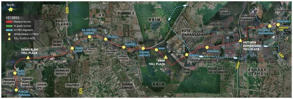
The Damansara-Shah Alam Elevated Expressway (DASH) is a 20.1 km, 3-lane, dual carriageway expressway that will commence at the Puncak Perdana U10 Shah Alam intersection and serve as a link for Puncak Perdana, Alam Suria, Denai Alam, Kampung Melayu Subang, Jalan Sungai Buloh, RRIM, Kota Damansara, Damansara Perdana and Mutiara Damansara. It will end at the Penchala interchange, linking road users to LDP and SPRINT highways. 12 interchanges will be built along the alignment. The proposed expressway is expected to support rapid developments along the alignment covering U10 Shah Alam, Subang, Kota Damansara and Damansara areas.
Proposed DASH Highway Route
Benefits of DASH
- As an alternative route for Persiaran Surian at Kota Damansara which has capped its road capacity
- The rapid development along Shah Alam and Jalan Batu Arang corridors require an additional road capacity
- As Subang Airport becomes the main low cost carrier terminal in 2015, DASH will become an alternative and easier route to the airport
- It will act as a link between east and west of Klang Valley by crossing over NKVE and linking existing highways namely GCE, LDP and SPRINT
- RRIM’s development in the area is expected to increase population by 300,000 which will cause congestion to the existing routes. DASH will be a solution to this problem
Denai Alam Residents Association (DARA) Facebook Page
Denai Alam Recreational Club (DARC) Webpage
Denai Alam Recreational Club (DARC) Facebook Page
LYN Denai Alam Current & Future Owners/Residents:
» Click to show Spoiler - click again to hide... «

This post has been edited by Xai-V-iaX: Feb 1 2013, 02:05 PM
 Quote
Quote


 . You're lucky to get that with that price. May I know how big is your land area?

 0.0575sec
 0.43
0.43
 7 queries
 GZIP Disabled